
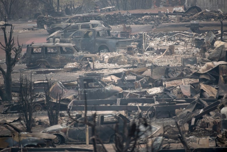
As wildfires continue to burn across the interior of British Columbia, thousands of residents have been forced out of their homes — many not knowing whether those homes will withstand the flames.
It’s a scenario seen increasingly not only across North America’s west coast, but in places around the world facing drier, hotter weather due to climate change. Scientists say such fires are only going to get worse in coming years.
That’s where astrophysicist Carlton Pennypacker comes in. Along with a team of fellow researchers at the University of California Berkeley, Pennypacker is determined to help address the growing wildfire threat.
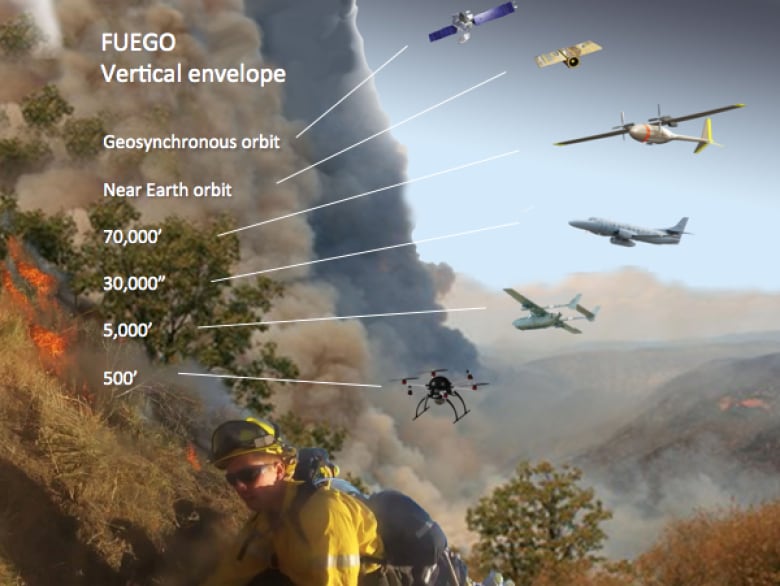
Since 2013, his team has been been working away in the lab to develop a system they call the Fire Urgency Estimator in Geosynchronous Orbit (FUEGO).
It harnesses innovative drone and satellite technology to help monitor wildfires in their early stages — long before they begin to burn out of control.
A smarter system
FUEGO can locate and track fires using drones, planes and satellites mounted with special infared cameras.
The software is able to pinpoint potentially threatening fires and immediately dispatch air tankers and ground firefighters to the area before they start to spread.
The future is quite optimistic on this.– Carlton Pennypacker
“There are basically about four simultaneous revolutions that really make this system possible,” Pennypacker tells Day 6 guest host Marcia Young.
“There’s the sensor, as cameras’ detecting elements have just gotten so good and so cheap. Unmanned aerial vehicles, or drones, have gotten much cheaper [and have] longer endurance. Image analysis software has gotten so much faster and cheaper because of advances in computing.”

All of that makes it easy to detect fires and send alerts to fire suppression forces, such as fire officials and forest crews, Pennypacker says.
While it will be a few years before FUEGO is fully operational, Pennypacker and his team have begun testing parts of the system and are hoping their work can eventually make a difference in the way wildfires are handled.
”It’s probably five years before we’ll have a huge effectiveness,” Pennypacker says. “I think we can have some modest effectiveness almost immediately. We’re not going stop all fires. [But] I think a lot of the pieces of the system are ready to go.
“The future is quite optimistic on this, and I think we have a lot of hope for doing this.”
From shining stars to burning blazes
Pennypacker’s background in astrophysics may not be the most obvious path to figuring out how to fight fires, but it was a key driver in helping him think of innovative ways to tackle the problem.
“I’ve spent my life using computers and sensors to detect small bits of light maybe a billion light-years away from us, which seemed to be transportable to detecting small fires from satellites or fire towers or drones,” he explains.
“All of the above will work at some level of effectiveness — some of it is working already. I think we can gradually over the next five to 10 years avoid the really heartbreaking stories [of the impact on people from such fires].”
Investment in prevention
Given how often residents are displaced, let alone the major financial and environmental effect on areas hit by rapidly spreading wildfires, Pennypacker believes investing in a system like FUEGO up front could potentially save regions billions of dollars in the long run.

“The whole system with cameras and everything, if we’re up at 80,000 feet, that might be a half-million-dollar system, but it will last for a decade,” Pennypacker says.
“California has somewhere between $6 and $8 billion in fire damage [per] year over a few years. We hope we can bring that number way, way down.”
Governments and fire officials around the world, including in Canada, have indicated interest in the FUEGO system, according to Pennypacker.
“Forestry Canada, we’ve had very encouraging discussions with them… and we’ve had some extremely satisfying and receptive discussions with some of our state assemblymen [in California],” he says. “So I think that that’s going to go forward.”
“Governments, you have to wear ’em down. But we’re prepared for this, and it will happen.”
by CBC Radio 15 July 2017